
A Vision for the Next Ten Years of Global-Scale Earth Science

BIOS reef systems ecologist Eric Hochberg was among the 60 scientists who contributed to a recent paper published by NASA in the scientific journal Remote Sensing of Environment. Hochberg said the paper represents “the link between the digital numbers recorded by satellites and the human interpretation of what it means” for a variety of environments covering Earth’s surface, including his own area of expertise, coral reefs and shallow water environments.
After two years, the comprehensive review paper of the NASA Surface Biology and Geology (SBG) Algorithms Working Group, representing the work of 60 scientists from 40 institutions in seven countries, was published last month in the scientific journal Remote Sensing of Environment.
BIOS reef systems ecologist Eric Hochberg, one of the contributing authors and editors, describes algorithms as the “processes that convert satellite data into meaningful products, such as maps that people can use and understand.” He said the review paper represents “the link between the digital numbers recorded by satellites and the human interpretation of what it means” for a variety of environments covering Earth’s surface, including Hochberg’s areas of expertise, coral reefs and shallow water environments. Other areas of interest included volcanoes, ice, human agriculture, tropical forests, estuaries, and wetlands.
The comprehensive review paper describes the mathematical processes, or algorithms, used to convert satellite data into meaningful products, such as maps that people can use and understand, for a variety of environments on Earth’s surface, including agriculture, coastal zones, and snow and ice.
Hochberg’s involvement began in 2015, when he was selected to participate in one of several panels convened by the National Academy of Sciences to provide guidance for what would later become a consensus study report titled Thriving on Our Changing Planet: A Decadal Strategy for Earth Observation from Space, or more simply the “Decadal Survey.” This report, which was released in 2017, is jointly sponsored by NASA, the National Oceanic and Atmospheric Administration (NOAA), and the United States Geologic Survey (USGS). Its goal is to generate recommendations from the scientific community to help prioritize the nation’s research activities, budget for the development of new technologies, and support inter-agency collaboration.
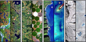
One of the report’s stated priorities was an SBG mission to measure ground and water temperature, snow reflectivity, active geologic processes, vegetation, and algal biomass, among other parameters. The report also recommended a specific technology for observing Earth called hyperspectral imaging, which measures hundreds of different colors at each pixel within the image (as opposed to the simple red, green, and blue of a digital camera). This is the same technology that Hochberg used in the four-year NASA-funded Coral Reef Airborne Laboratory (CORAL) mission to address fundamental questions about reef ecosystem science.
In 2018 and 2019, a number of working groups were formed within the NASA SBG mission to help the agency explore all implementation possibilities, including the algorithm working group that would eventually go on to publish the review paper that Hochberg describes as “the current status of biology and geology observing algorithms.”
While SBG hasn’t formally been approved to proceed as an official NASA mission, it will likely launch as a single satellite or a small constellation of satellites toward the end of this decade. By leveraging the most current techniques and technologies that scientists use to image the Earth’s surface from the air and space, SBG will help address the scientific priorities identified by the Decadal Survey. This includes measuring snow and ice accumulation; studying evolving landscapes such as volcanic eruptions and landslides to better address hazard risks; monitoring the health of inland and coastal ecosystems; and helping agencies in the management of agriculture, natural habitats, water resources, and urban development.