
Deepgliders: The Next Frontier in Ocean Exploration
In 1872 the H.M.S. Challenger embarked upon a four-year scientific journey to survey and explore the world’s ocean, including the deep sea in the great ocean basins. During this time, her crew and scientific staff collected 492 depth soundings and 263 observations of water temperature—an impressive feat considering their equipment consisted of a plumb line marked in 25 fathom intervals and several thermometers (including a reversing thermometer, which could measure temperature at specific depths). The resulting 50-volume report laid the foundation for the modern fields of oceanography.
Fast forward more than 140 years and scientists today are exploring the ocean on scales, and with technologies, that few aboard the Challenger would be able to imagine. Take this recent example from the University of Washington School of Oceanography, where Charlie Eriksen and his colleagues deployed an autonomous underwater vehicle (AUV) called a Seaglider to conduct repeat surveys of Ocean Station P—a site 850 miles west of the British Columbia, Canada coast in the center of the Gulf of Alaska, visited a few times annually over more than half a century. Over the course of 292 days the Seaglider—outfitted with a CTD (a sensor that measures conductivity, temperature, and depth)—collected 3500 profiles of the water column as it traveled 5528km through the water. At the end of three Seaglider missions, Eriksen and his team had 18 months of temperature measurements in the top 1000m of the water column, with most of the work being conducted by a bright pink, 1.8m-long underwater robot weighing in at just 110 pounds.
Now the Deepglider is poised to be one of the next great innovations in decades of technological advancements in the field of oceanography and ocean engineering. While the first generation of underwater gliders, such as Seaglider, are restricted to a depth of 1000m, Deepgliders promise to able to explore the ocean at depths up to 6000m, with 10,000km of horizontal range (equivalent to ¼ the circumference of the globe) and mission spans of over one year. These instruments are designed specifically to make routine full-ocean depth hydrographic surveys, which can help scientists understand much about the physical oceanographic properties of the deep ocean. Already in testing, Deepgliders have shed light on a variety of oceanic processes, including the impact of seafloor features, such as ridges, on geostrophic currents.
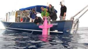
Recently, Charlie Eriksen and his team visited BIOS to conduct an extensive field test of Deepglider in the deep waters off Bermuda. On Thursday, March 20, 2014 the University of Washington group deployed one with instructions to travel back and forth to Hydrostation S—BIOS’s deep-water research mooring located 15 nautical miles southeast of Bermuda. The plan is for the glider to transit these waters, collecting and sending data along the way, until April 10th or 11th, when the R/V Atlantic Explorer will leave port and head to the Bermuda Atlantic Time-series Study (BATS) site. At this time, the glider will be sent new instructions (via satellite) to travel southeast toward the BATS site and begin conducting repeat surveys around the site in a butterfly (or bowtie) pattern. As it turns out, the two BIOS time-series sites are crucial components in the glider’s field test, as researchers can compare measurements from the glider’s sensor with measurements taken at the sites and during the BATS cruise.
Eriksen and his colleagues plan to bring a second deep glider to Bermuda in the coming months and deploy it in a similar manner, allowing them to test both gliders at once. In the meantime, Eriksen keeps a keen ear out for the “ping” of a new message on his cell phone—the signal from the glider that it has surfaced, sent data, and is still “happy.”